Conducting A Resistivity Survey

Page Index

[ Archaeological Geophysics Page ]

Introduction

This page will explain how to perform an archaeological geophysics survey using modern resistivity equipment. It assumes that you have already read the page on Setting Up A Grid. Resistivity in archaeology is the cheapest and easiest to use form of geophysics, so it is popular with many local societies. It can pick up walls and ditches, though magnetometry tends to pick up ditches better. It doesn't pick up metal or burning in the way that magnetometry does, but neither does it cause interference when you are not looking for these.

Equipment

The equipment dealt with in this page is of the modern variety commonly used in archaeological geophysics, i.e. a twin-probe meter with a data logger and automatic logging. The twin-probe array consists of two mobile probes, usually mounted on a frame and a long cable leading to two fixed probes which are placed some distance away from the survey area. The equipment is cheap enough these days to make dealing with anything else more trouble than it is worth. Besides, if you have enough knowledge to build your own meter without such features, then a page such as this is not going to tell you much you do not already know.

Conditions

As resistivity picks up the level of moisture in the soil, two surveys carried out on the same spot will not necessarily give the same results as the conditions will change over time. The soil condition is a limiting factor when using Resistivity. Sometimes, decent results will only be obtained at certain times of the year, under certain weather conditions. If a site is too dry, you will get no contrast in the readings because everything will be equally dry, despite what features are present. Conversely, if a site is too wet, there will again be no contrast because buried features will have little effect on the low resistance provided by the sodden topsoil.

Deciding on the best time to do a survey, if you have the luxury of making such a decision, is not only dependant on the local geology and how quickly the site will dry out. If the topsoil is thin or the geology drains well, such as with a sandy geology, then the site will dry out quickly and it is best not to wait too long after any rainy season before doing a survey. If the topsoil is thick or the geology drains badly, such as with clay, then it is best to wait for the site to dry somewhat before doing a survey.

The best way to judge is by testing the sort of readings you are getting, especially if you have a known archaeological site to hand. You can test the same feature over time to see how the contrast changes with the weather without actually doing a survey.

Other geological features can be problematic. If the background geology is not consistent across the site then problems with interpretation can occur. For example, is you have a chalk bedrock containing pockets of clay with flints, then the geology itself will give a great contrast in readings, making archaeological features difficult to pick out. Rocks that have a lot of fracturing will produce a similar effect. Another property of some rocks such as chalk is their permeability. In especially dry conditions, chalk will actually let moisture back up into the soil, but if there is a ditch, especially one containing blocky material then this process is disturbed, which will actually leave the ditch with a higher resistance than the surrounding area! Even without a particularly problematic bedrock, you can encounter problems. Uneven drift geology such as alluvium and colluvium can generate a wide range of readings across the site. This can fortunately be remedied using a high pass filter when processing your results, but if the features you are looking for have not made it down to the bedrock and were backfilled with the same material from which they were dug, features may not show up at all. Only with experience will you discover the quirks of your local geology.

Equipment Setup

One aspect of equipment setup to be considered is the interference filtering. As well as the electric current produced by the machine, the ground can have currents generated by nearby buildings. This interference can cause incorrect readings, but modern equipment has filters to help screen these out. The more time the machine takes to take a reading, the more accurate it will be, as it has more time to find the average reading. This tradeoff between speed and accuracy should be considered before you start the survey. Modern machines have several settings, usually three, that will allow the machine different amounts of time to make its mind up about the reading. A slow speed should be chosen if you are in a heavily built up area where there is a lot of ground interference. The middle speed is suitable for a semi-rural area, such as a small village or farm area. A fast speed should be used if you are out in the middle of a field somewhere. If you have a machine which tells you the reading it has taken, then this can be checked against the reading currently showing on the meter. If you have several cases where they are significantly different, then a slower speed may be needed.

Fixed Probes

One aspect of a survey that can cause confusion is dealing with the fixed probes. Getting it right can save time and hassle. Firstly there is the matter of the position of the fixed probed in relation to the grid you are going to be surveying. The fixed probes should be placed roughly in the centre of the grid square adjacent to the grid square you are surveying and firmly into the ground. Which adjacent square to choose should be dependant on which direction you are surveying. If you put the fixed probes in the square next to the first line you will survey, then the cable that joins the fixed probes and the meter will always be behind you and out of the way. If you don't do this, you will have problems with the cable getting in the way of the strings used to mark out the points in the grid. It should be noted that it is possible to survey three grid squares without moving the fixed probes as shown in the diagram below.

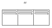
Fixed Probes in Relation to Survey Grids


The distance between the two fixed probes in the ground affects the readings you will get. In resistivity, there are no absolute readings, everything is relative. Needless to say, moving the fixed probes can cause problems if done incorrectly, so when moving the fixed probes to survey a new set of squares, a few basic rules will keep the problems to a minimum. The reason for having the fixed probes is because of the problem of variable contact with the ground using the mobile probes. If you had just the mobile probes, then the readings you get would be dependant on the amount of contact the probes had with the ground. To enable the equipment to work out exactly how much contact with the ground you have and give a true resistance reading at that point, it uses the fixed probes as a reference. These calculations which I will not go into here, mean that the distance between the two fixed probes affects the reading you will get. If the fixed probes are close together, you will get a high reading, if they are far apart, they will give a low reading.

When you start a survey, the probes should be about a metre apart. If you are only surveying for a day, this need not be accurate, but if you are surveying over the course of several days, then measuring the distance between the fixed probes to exactly a metre at the start of each day will help reduce the differences in average readings between grid squares over the course of the survey. If you don't do this, then when the data is processed, the squares surveyed on one day will look darker then another. Whilst software can correct these problems, it is best to keep the error to a minimum in the first place. Over the course of a single day, the discrepancies encountered by moving the fixed probes can be rectified by using the readings on the meter to make sure the fixed probes are set up correctly in their new position.

To move the fixed probes to a new position, place the mobile probes firmly in the ground at a point roughly in the middle between the point where the fixed probes currently are and the point where you want to move them to. Make a note of the reading currently showing on the meter and then move the fixed probes to their new position, making sure that the mobile probes are not moved. When the fixed probes are in position, you will see a reading on the meter which will probably be different than the one you had before. You now need to move the probes closer together or further apart until the reading is roughly the same as the one you made a not of before moving the fixed probes. Doing this will stop any errors caused by moving the fixed probes. It should be noted that moving the fixed probes in the way means the two probes will not necessarily be the same distance apart as in their original position. This doesn't matter too much, but if the distance apart has changed wildly, then you have probably picked a bad spot to put your fixed probes. If the distance between the old and the new points for the fixed probes is too far for the cable to stretch, then moving the fixed probes by this method will not work and you will have to get a rough match by measuring the exact distance between the two fixed probes in the old position and making the distance apart the same in the new position.

The Survey Itself

Once you have set up your grid, the survey strings, the meter and the fixed probes, you are now ready to do the survey itself, and having done all that, is mentioned, there is not much to say. First of all, don't forget to delete any grids from a previous survey that have all been processed.

Regarding the number of people needed to do a survey, here is a description of what you can get done. Don't forget to get people to swap between different jobs to avoid boredom/fatigue. The jobs that need doing are setting up the grid, operating the mobile probes, holding the cable so it doesn't drag, moving the survey strings and moving the fixed probes when necessary.

One Person: Moving the strings and pulling the cable around by yourself is a struggle and time consuming. If it's just you, forget it.
Two People: With someone holding the cable things are a lot easier. When you need to move a string, make sure the mobile probes are firmly in the ground and are not going to fall over and you can have one person can grab each end of the string. For extra speed, the person holding the cable can run back to the end of the string before the person holding the mobile probes reaches the end of it. It is also quicker if you survey two strings (if you have them) and move both at once. Quite slow and tiresome.
Three People: Better still, you can have one person permanently at the far and of the strings and the person holding the cable can move the other end of the string, leaving the person with the mobile probes free to start immediately on a second string if you are using one.
Four People: Ideal. With two people permanently on the strings across the grid square, the strings at the edge of the grid square can be moved as soon as the two surveyors start on the last string (or second to last if you have two) meaning there is little time wasted between each grid square.
Five Or More: With more people than is needed to do the survey itself, you can have people setting up grid squares whilst the survey is starting. After the grid squares have been set up, people can take breaks. Too many people and boredom sets in.

[ Archaeological Geophysics Page ]