| Harrow Hill |
| Map Ref : TQ082100 |
| Subject List | Archaeology |
|---|---|
[ Sussex Main Page ]
|
|
| Name Derivation |
|
HARROW HILL: From Hearg (Hilltop Heathen Temple)
Note: The derivation of this name is not certain as no early forms survive
(Coates 1980 p.309), but it is entirely possible that this an instance of
a Pagan Saxon Place Name. The name is first recorded
on an 1813 Ordnance Survey map. It was known to some locals as Harry Hill
(Curwen & Curwen 1922 p.29).
NEW BARN DOWN: Note: The name of this hill is simply derived from a barn that once stood on its slopes. The barn is no longer there. |
|
| Archaeology | ||
|
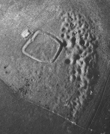
Introduction Harrow Hill lies within the Downs north of the village of Patching in West Sussex, with the modern coastal resort of Worthing further to the south. The hill rises to 168 metres above sea level and is roughly triangular in shape, with spurs leading north, south-east and south-west. The earliest remains on the hill are Neolithic flint mines, followed by a small settlement on the south-eastern spur in the Bronze-Age, and an earthen enclosure on the summit of the hill in the Late Bronze-Age. The Harrow Hill flint mines are at the end of a chain of such mines on the block of downland between the rivers Arun and Adur, the others in the chain being at Blackpatch, Church Hill and Cissbury. A square pond, constructed in 1899 lies down the hill to the south-west whist a modern reservoir now sits on the west side of the enclosure. Occasional isolated pits on the hill were used for chalk extraction for marling (Crawford 1926 p.148).
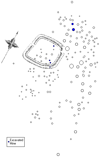
There is a very rich archaeological landscape around Harrow Hill. As well the Bronze-Age settlement and field system on New Barn Down, a spur on the South-East side of Harrow Hill (TQ 100087), another Bronze-Age settlement has been found on nearby Cock Hill (TQ 089097), along with a field system bounded by barrows (Ratcliffe-Densham 1961 p.78). The nearest set of flint mines are on the southern slope of Blackpatch Hill (TQ 094088), which also boasts another small settlement and field systems on its western edges. The spur to the north and north-east of Harrow Hill itself also has some earthworks (Ratcliffe-Densham 1961 p.79) and Barpham Hill to the west has some significant earthworks of the 'Cross-Dyke' type (TQ 066098). Neolithic Flint-Mines The earliest known activity on Harrow Hill is a large set of Neolithic Flint Mines. It has been suggested that the earliest of these are concentrated on the summit of the hill and were open cast quarries, now represented by shallow pits (Barber et. al. 1999 p.33) with the slightly later mines which led down into galleries, while occasionally present on the summit, are mostly concentrated just below it, in an arc stretching from the north to the south-east. Whilst many have been ploughed away, 245 were surveyed by the Royal Commission (Oswald 1994 p.6).
Many of the quarries and mines have been cut and enclosed by the Late Bronze-Age Enclosure which sits on the summit. Within the enclosure, there are many deep mines, though the surface features are shallow. It is therefore entirely possible that many of the shallower features on the summit have actually been backfilled to the point of almost disappearance, indeed it has been suggested that the area around the enclosure was levelled or ploughed before the enclosure was built (Oswald 1994 p.9), perhaps by the farming culture centred on New Barn Down. The depth of mines found may relate to the stratigraphy of the flint seams, which fall away to the south (Field 1997 p.61). The first excavations in flint mines, though not to any depth, were by a Mr. Collyer (Curwen & Curwen 1922 p.31), who found puddled clay at the top of three shafts along with water snails, which suggest they were filled with water at some point. In others, he found the remains of animal bones and teeth, whilst within the enclosure, he found the top of another shaft which had been backfilled with chalk blocks.
The Curwens (1926 p.103) excavated a single shaft to the north of the enclosure in 1924 and 1925. They found that the mine exploited three seams of flint, one near the surface, another half way down with only a small gallery leading from it, and the lowest seam, at the floor level of the shaft base, where most of the flint extraction took place.
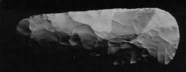
The shaft was roughly oval and 22½ feet deep and had six galleries leading from its base. The top of the backfilled shaft contained animal bones and oyster shells, probably from a much later date than the mines itself. Under the chalk rubble was found tools, such as ox shoulder blades used as shovels, antler picks and hammers used to make tools from the mined flint. Some axe roughouts were found along with flint flakes from their production along with charcoal (mostly ash and willow), possibly from a fire. The surrounding galleries contained a similar set of artifacts.
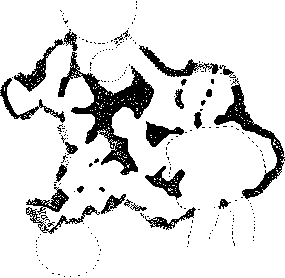
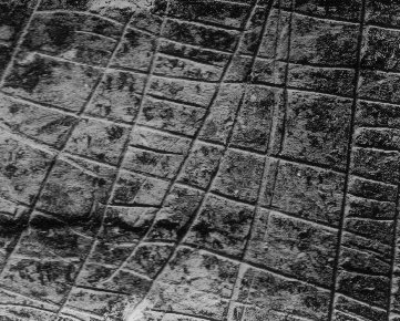
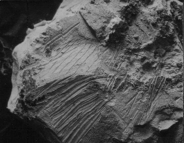
The walls of the shaft and galleries were peppered with pick marks from the antler picks and were also burned by lamps in places, though this may have been due to modern visitors to the excavations. A final point of interest is some graffiti on various walls and on blocks consisting of several sets of parallel and perpendicular lines. These were mostly found near the entrances to the galleries, but their purpose remains obscure. The scratches on the second image below seem like a sharp object such as a flint implement is being tested, but the first is of a much more careful design. Curwen (1927 p.162) also suggests tally marks, though this is difficult to see in the second example shown below. Other theories such as gallery maps (not really representational) or cultural ownership marks (too diverse when several instances together, unlike pottery) are also unsatisfactory (Russell 2001 p.88). Similar scratches have been found on pieces of chalk deposited at some Causewayed Enclosures, prompting the idea that they are ritual in some way.
During his excavations within the enclosure, Holleyman (1937 p.237) excavated several mine shafts. The first, which was partially cut by the enclosure ditch and backfilled with chalk rubble, exploited two seams of flint. Three flint axes, one partially polished, and some pieces of antler were found in the shaft, though nothing was found in the single gallery leading from the shaft. The second shaft was north of the first, and under the rampart. Four galleries led from its base and a further one intruded from another shaft. The remains of a large ox from the neolithic were found high up in the shaft, whilst flint tools, antler and the remains of tool production were found in the bottom of the shaft. The top of a third mine just to the north of the second one was partially uncovered, but not excavated. The fourth shaft excavated by Holleyman was near the north side of the enclosure and had five galleries radiating from it, only one of which was excavated. Nevertheless, no less than 33 flint axes were found in the shaft along with a hearth and fragments of an ox scapula used as a shovel. In 1982, P.J. Felder excavated a shaft just to the north-west of Curwens shaft (McNabb et. al. 1996 p.22). He discovered that the area around the shaft had been completely removed in an open cast mining operation to exploit the higher of the two seams of flint available in the area. Several small shafts had then been sunk in the base of this quarry to the lower level of flint, culminating in the large shaft that Felder initially excavated, which was the only one visible on the surface. Felder found that the galleries from this shaft connected with those from Curwen's shaft to the south-east, some of which contained more of the graffiti described by Curwen. Six sets of radio carbon dates from Felder's main shaft gave dates from the end of the fourth millenium BC, making Harrow Hill one of the earliest known flint mines (Barber et. al. 1999 p.2). Excavations in 1984 by Greg Bell (McNabb 1996 p.26) just to the north of Felders shaft attempted to find evidence of flint knapping around the shaft. Three trenches were opened, the middle one of which produced some evidence of in-situ knapping, but not a large knapping floor. Several axes in various stages of production were also found. New Barn Down New Barn Down is the name given to the southeastern spur of Harrow Hill, one which evidence of early settlement has been found. The younger Curwen along with the Worthing Archaeological Society excavated several areas here in 1933 (Curwen 1934a p.215,1934b p.137). One pit he excavated revealed a pit dwelling consisting of an oval pit 8½ by 6 feet and 2 feet deep with a smaller round pit abutting it on the western side measuring 4 feet across and 9 inches deep. Signs of burning were evident throughout both pits and a hearth was visible on the northern side of the larger pit, containing some broken Neolithic flintwork. Early Neolithic Windmill Hill pottery was found on the floor along with a small amount of animal bone and parts of two sandstone rubbers. The flint implements found were contemporary with the flint mines on the top of the hill, suggesting the pit was occupied by the flint miners themselves.
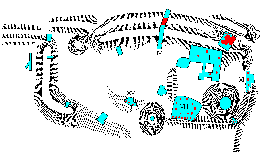
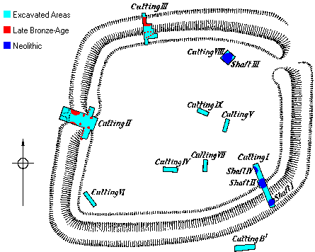
The enclosure shown above is a Bronze-Age enclosure slightly uphill from the Neolithic pit dwelling. It is part of a greater complex including field systems, a trackway, barrows, pits and an unexcavated oval enclosure just to the north-west of the enclosure. The remains of two roundhouses were found in trenches III and VIII whilst VIII, XI and XV revealed postholes from a palisade around the enclosure. The flat bottomed ditch on the north side was revealed by trench IV, along with a pit, possibly from another hut. The postholes defining the two huts held upright posts and the huts were dated to the Bronze-Age by a quantity of Deverel-Rimbury pottery. Quern fragments were also found in both huts, while a bronze knife and spear head were found in Trench VIII and a chalk cup in trench III. The amorphous feature in trench V contained pottery, piles of flint and a bone tool, and Curwen (1934b p.148) thought this might be a cooking area, though he didn't find a fire. The Enclosure On the summit of Harrow Hill, amongst the Neolithic flint mines, sits a small Late Bronze-Age Hillfort or enclosure. Unusually for hillforts, it is almost square, with only the south-east corner being more rounded. The single ditch and bank, the latter being only about 5 feet high, are interrupted by two entrances, one in the western rampart and one possible one in the north-east corner. The only archaeological excavations on the hill that related to the enclosure were performed by Holleyman (1937 p.230), who opened several trenches within the enclosure and through the rampart and ditch.
The trench in the gateway to the west (II) revealed the ends of the two ditches either side of the causeway as well as a series of postholes forming a palisade and a gate (Holleyman 1937 p.233), one of which contained sherds of was thought at the time to be Early Iron-Age pottery (Holleyman 1937 p.244) but is now generally considered to be Late Bronze-Age (Hamilton & Gregory 2000 p.66). The postholes may represent part of the 'fortifications' or they may be the remains of a pre-rampart palisade enclosure. Sealed below the rampart on the old turfline was found a large quantity of charcoal, which may represent burning to clear the area before the enclosure was constructed. No charcoal was recorded in the postholes of the palisade, so it was not this that was burned. The trench through the rampart on the north side of the enclosure (III) revealed the flat bottomed ditch and two rows of postholes, only 3 inches deep. Trenches which revealed the shafts of Neolithic flint mines include Trench VIII within the camp and Trench I through the rampart to the south-east which revealed three Neolithic flint mines, one under the rampart and one truncated by the ditch, which had more of a V shaped profile than on the northern side. The molluscan analysis of soils relating to the enclosure suggest scrub and grassland (Holleyman 1937 p.246), whilst charcoal was mainly of oak and hazel, which was possibly cleared by burning as suggested by the charcoal found under the rampart near the entrance. The Romans There seems to have been some activity on Harrow Hill in Roman times. As well as oyster shells and the odd Roman coin (1st Century) from the top of Harrow Hill, Ratcliffe-Densham (1972 p.126) found remains of Romano-British settlement on the south side of the hill. The Saxons As well as the possible use of the Late Bronze-Age enclosure as a Saxon shrine, a pair of barrows near the New Barn Down settlement were excavated by Curwen (Curwen 1934b p.157) and turned out to be Saxon in origin. The earliest barrow of the pair was a very faint disc barrow containing a skeleton with its head to the west and buried with a Scramasax (a long knife) which was dated to the 7th or 8th century. The other barrow, a bowl barrow, had its edge overlaying the previous barrow to an extent, thus being of a later date, though the grave pit had been disturbed by treasure hunters who had missed the other barrow, and left the human bones in the pit strewn about. |
|
| Folklore |
|
Fairies
Harrow Hill has the distinction, along with many other sites, of being known as
the last place inhabited by Fairies in England. An
old woman who lived at Lee Farm related to Reverend Evans (1934 p.432)
that according to people before her time, described the hill as being such. They
finally left the site when the unbelieving archaeologists came to the hill and
started digging, so now they no longer dance there in the summer twilight.
|
|
| Bibliography |
|
Barber, M., Field, D. & Topping, P. : The Neolithic Flint Mines of England, English Heritage 1999 Coates, R. : Studies and Observations on Sussex Place-Names, SAC Vol. 118 1980 Crawford, O.G.S. : Notes on Air Photograph of Harrow Hill, SAC Vol. 67 1926 Curwen, E. & Curwen, E.C. : Notes on the Archaeology of Burpham..., SAC Vol. 63 1922 Curwen, E. & Curwen, E.C. : Harrow Hill Flint-Mine Excavation 1924-1925, SAC Vol. 67 1926 Curwen, E.C. : The Old Flint Mines Of Sussex, SCM Vol. 1, No. 4 1927 Curwen, E.C. : A Flint-Miners Dwelling and a Bronze-Age Farm in Sussex, Antiquity Vol. 8 1934a Curwen, E.C. : A Late Bronze-Age Farm and a Neolithic Pit-Dwelling, SAC Vol. 75 1934b Curwen, E.C. : Photographs, Working Papers, Box 4, Sus. Arch. Soc. Library Ratcliffe-Densham, H.B.A. : An Anomalous Earthwork of the Late Bronze Age, on Cock Hill, SAC Vol. 99 1961 Ratcliffe-Densham, H.B.A. : Finds from Harrow Hill, Patching, SAC Vol. 110 1972 Evans, A.A. : A Countryman's Diary, SCM Vol. 8, No. 7 1934 Field, D. : The Landscape of Extraction, in Topping 1994 Hamilton, S. & Gregory, K. : Updating the Sussex Iron Age, SAC Vol. 138 2000 Holleyman, G. : Harrow Hill Excavations, 1936, SAC Vol. 78 1937 Mawer, A & Stenton, F.M. : The Place-Names of Sussex (2 vols), Cambridge U.P. 1929 & 1930 McNabb, J. et. al. : An Archive REport on Recent Excavations at Harrow Hill, SAC Vol. 134 1996 Oswald, A. : Harrow Hill, West Sussex, RCHME 1994 Russell, M. : The Early Neolithic Architecture of the South Downs, BAR Brit. Ser. 321 2001 Topping, P. (Ed) : Neolithic Landscapes, Oxbow Monograph 86 1997 |
[ Sussex Main Page ]